Scenic Route Map & Directions (Print-Friendly)
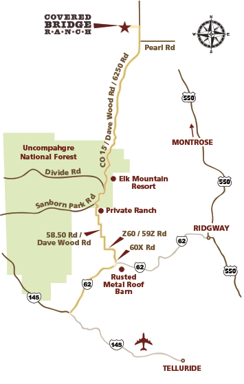
FROM DOWNTOWN TELLURIDE head West onto CO-145. At intersection, turn right onto CO-62 heading East. In 8.7 miles, as you come around the corner, on the right you will see a rusted metal roof barn peaking over the road’s edge. Directly across from the barn on the left is the turn off for 60X Rd. Make a sharp left onto 60X Rd heading up a hill.
FROM DOWNTOWN RIDGWAY head West on CO-62 for 14.2 miles. On your left you will see a rusted metal roof barn peaking over the road’s edge. Directly across from the barn is the turn off for 60X Rd. Make a slight right onto 60X Rd heading up a hill. Curve around to your right and continue on 60X Rd for 2 miles. Turn left onto Z60 Rd, which becomes 59Z Rd. Over the next 3.5 miles, 59Z Rd curves right, then left, then right and becomes 58.50 Rd/Dave Wood Rd. You will again curve left on 58.5 Rd/Dave Wood Rd and after a short distance, turn right onto Dave Wood Rd. After 2.5 miles, on the right side of the road is a dark brown collection of buildings (Private Ranch) at the base of a hill. Continue on Dave Wood Rd and follow the road up the hill into the trees. At the intersection, turn right onto Sanborn Park Rd and enter the Uncompahgre National Forest for 2.9 miles. At the fork in the road, stay to the right and continue on to CO Rd 15/Dave Wood Rd. You will remain on this road for 14.7 miles. The road turns into a paved road after leaving the Uncompahgre National Forest heading downhill. At the bottom of the hill, on your left you will pass Popular Rd and a Chipeta water station. Shortly thereafter on your right you will pass Pearl Rd. The Covered Bridge Ranch gate entrance is immediately on the left.
* Note: These roads are not plowed, so this is a route best taken in the fair weather months.